
Furuno FAR-3200 & FAR-3300 Series Chart Radar Operator’s Manual – Full PDF Download
Original price was: $59.95.$39.95Current price is: $39.95.
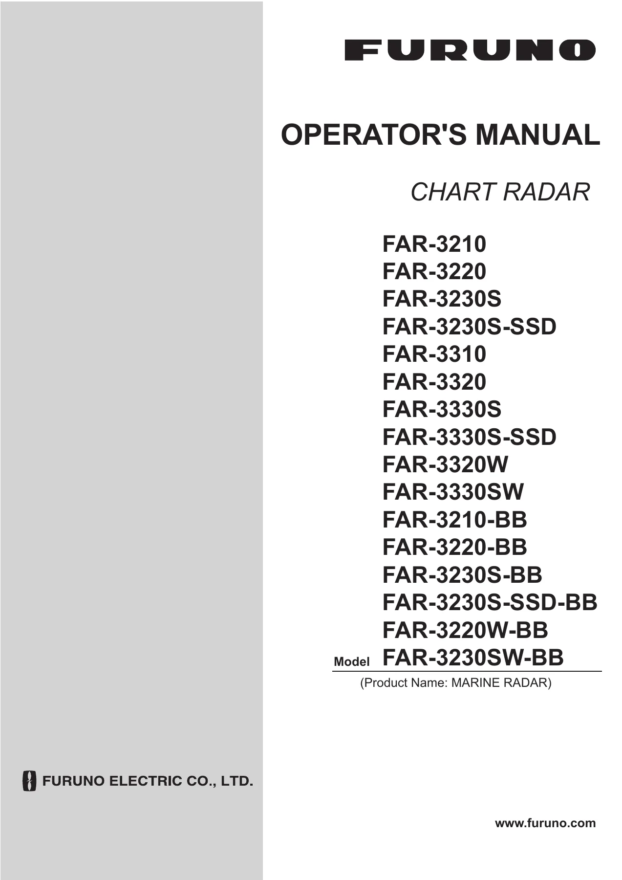
Complete 553-page PDF operator’s manual for the FURUNO FAR-3200 / FAR-3300 Series Chart Radar. Covers FAR-3210, FAR-3220, FAR-3230S, FAR-3310, FAR-3320, FAR-3330S, FAR-3320W, FAR-3330SW, solid-state SSD models and all BB variants — every menu, TT/AIS function, chart operation, alert and maintenance procedure.
Description
The FURUNO FAR-3200 / FAR-3300 Series Chart Radar Operator’s Manual is the complete 553-page bridge reference for the entire FAR-3xx0 line — magnetron X-band, magnetron S-band and solid-state S-band. It covers the FAR-3210, FAR-3220, FAR-3230S, FAR-3230S-SSD, FAR-3310, FAR-3320, FAR-3330S, FAR-3330S-SSD, the wide-transceiver FAR-3320W and FAR-3330SW, and all the black-box ‘-BB’ variants of each. Every chapter is written for the officer of the watch, the ETO and the technician who has to power up, tune, operate, configure and troubleshoot this radar in real sea conditions, not just flip through a quick-start card.
File Details
- Manual type: Operator’s Manual
- Brand / manufacturer: FURUNO Electric Co., Ltd. (Nishinomiya, Japan)
- Model series: FAR-3200 / FAR-3300 (FAR-3000 series)
- Publication No.: OME-36160-H (REFU)
- Language: English
- File format: PDF
- Page count: 553 pages
Chapters Covered
- 1. Operational Overview
- 2. Radar, Chart Radar Operation
- 3. Target Tracking (TT)
- 4. AIS Operation
- 5. Radar Map and Track
- 6. Chart Overview
- 7. How to Manage Charts
- 8. How to Control Chart Objects
- 9. Vector (S57) Charts
- 10. C-MAP Charts
- 11. Chart Alerts
- 12. Routes
- 13. User Charts
- 14. How to Monitor Routes
- 15. Navigation Tools
- 16. Navigation Sensors
- 17. AIS Safety, Navtex Messages
- 18. TT and AIS Displays
- 19. Recording Functions
- 20. Alerts
- 21. Parameters
- 22. Settings Menu
- 23. Common Reference System
- 24. Conning Displays
- 25. Maintenance and Troubleshooting
- Appendices 1 to 4: Menu Tree, Abbreviations and Symbols, Data Color and Meaning, Alert List
- Specifications
Chapters 1 and 2 — Control Layout and Radar Operation
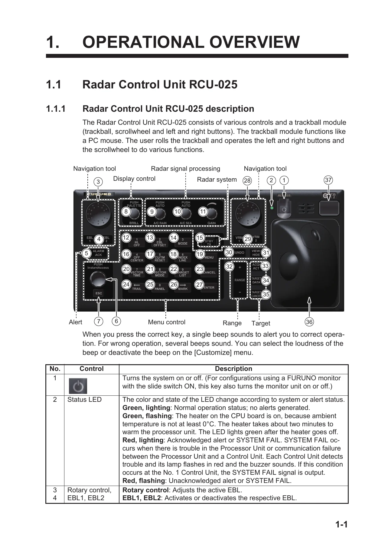
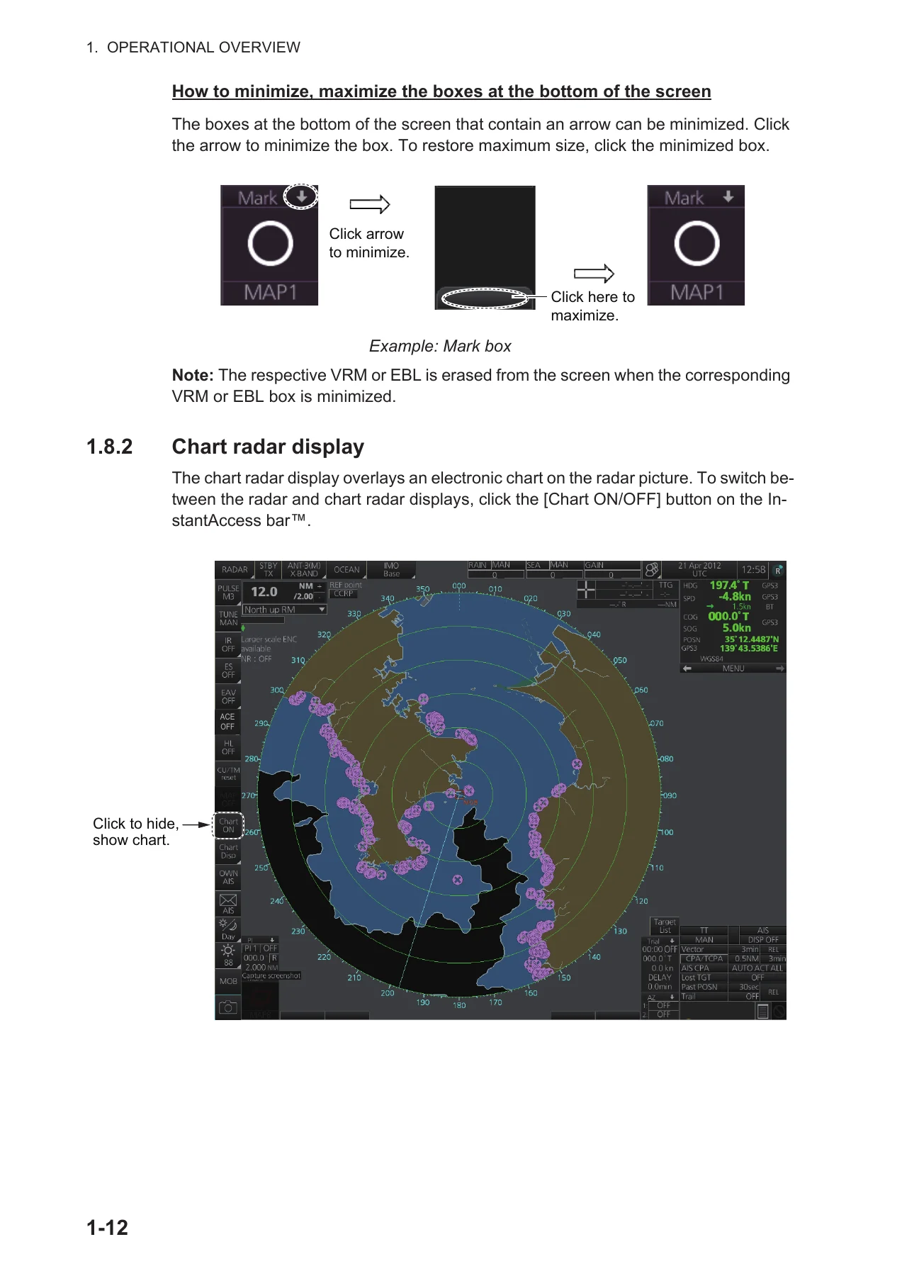
Chapter 1 lays out the physical and on-screen controls: the RCU-025 Radar Control Unit with its rotary EBL/VRM controls, ten-key and function keys; the RCU-026 Trackball Control Unit and its trackball module; and the EC-3000 Processor Unit, with mains/power switches, RJ45 LAN ports and DVD drive. From there it walks through power-up, palette selection, brilliance and backlighting, display modes, status bar, InstantAccess bar, the eight-menu tree, context-sensitive menus, sensor/datum box, ship speed and heading input, MOB, position offset, time format, screenshots and the ten user profiles. Chapter 2 is the practical heart of the manual: transmit, tune (auto/manual for magnetron), pulse-length selection per range, GAIN, A/C SEA, A/C RAIN, interference rejector, echo stretch, echo averaging, the Automatic Clutter Elimination (ACE) mode, noise rejector, wiper, second-trace echo rejection, presentation modes (head-up, STAB head-up, course-up, north-up, stern-up, north-up TM), range scales, VRM and EBL measurement, offset EBL, target trails, parallel index lines, zoom, markers, watch alert, information box, interswitch, dual radar, performance monitor, magnetron reset, CCRP, drop marks, anchor watch, SART, alerts, echo area and echo color, icing prevention, and the chart radar functions. Radar observation theory — minimum/maximum range, radar horizon, resolution, false echoes, RACON, Radar Target Enhancer, solid-state behaviour — closes the chapter.
Chapters 3 and 4 — TT and AIS
The TT chapter covers manual and automatic acquisition on up to 200 targets, acquisition zones (fan-shaped and polygonal), reference targets for echo-referenced speed, symbol attributes and colours, per-target data display, vector motion and length, past positions, set and drift, CPA/TCPA alarm, lost-target alert, dynamic and static trial manoeuvres, TT simulation mode and the factors that degrade tracking accuracy. The AIS chapter picks up with activation and sleeping of targets, DISP ALL / DISP FILT / DISP OFF filtering, pop-up data, expanded AIS data, AIS CPA/TCPA, symbol colour and brilliance, AIS lost-target, past positions, vector modes, association with TT, voyage data input (nav status, ETA, destination, draught, crew, cargo category), transmitted and received AIS safety messages, and the static own-ship data page.
Chapters 5, 6 and 8 — Radar Map, Chart Overview and Object Control
Chapter 5 explains the ten radar maps and their 4,000 points per map, entering marks and lines, map comments, erasing/copying marks in bulk or by area, export and import of map files to USB, radar-map features on/off, the ship’s track and its save interval, route and user-chart overlay on the radar picture. Chapter 6 is the chart display overview: modes, chart operating modes (NAVI / CHARTS / PLAN), chart scale, presentation modes, cursor box, silent mode, true-motion reset, VRM and EBL on the chart, split screen, datum handling, sensor settings, and the departure setup checklist. Chapter 8 controls chart object visibility: shallow/safety/deep contour and safety depth, the general/standard/other/text/NtoM pages, display base, predefined IMO BASE / IMO STD / IMO ALL settings, and the symbol display pages for general, tracking, route, mariner and targets.
Chapters 7, 9 and 10 — Chart Management, S57 and C-MAP
Chapter 7 is the install and manage chart chapter: public keys, ENC licenses and charts, C-MAP database and licenses, C-MAP DL, eToken registration, chart cell catalog and grouping, cell status reports, chart installation/update history, publisher notes, permit expiry, backup and restore of licenses, manual chart updates (insert, delete, modify, review update symbols), chart data synchronization between FMD/FCR/FAR units, and reconverting SENC charts. Chapter 9 covers S57 vector charts, the ENC/SENC definitions, chart viewing dates and seasonal dates, the presentation library (pslb04_0.dai, IHO presentation library Ed 4), pick reports, and the Admiralty Information Overlay (AIO). Chapter 10 handles C-MAP registration, ordering, licenses, troubleshooting, the C-MAP Dynamic Licensing service, chart legends, permanent warnings and Notice to Mariners.
Chapters 11, 12, 13 and 14 — Alerts, Routes, User Charts and Monitoring
Chapter 11 defines chart alerts, the safety contour, object-level alert priority (A / W / C), the own-ship look-ahead area, and route-planning chart alerts. Chapter 12 is the complete route-planning guide: new route creation, waypoint editing, alert parameters, check results, optimization (MAX speed / Time table / MAX profit / MIN cost), cost parameters, SAR patterns (expanding square, parallel tracks, sector search), the route bank, import/export in FAR / FEA-2×07 / RTZ / CSV / ASCII formats, route transfer over LAN, and printed route reports (WPT table, Full WPT, passage plan). Chapter 13 covers user charts — tides, lines (coast, nav, route, depth), clearing lines (NMT/NLT), areas, circles, point and text labels, Notes, sync, import/export, reports. Chapter 14 walks through route monitoring, waypoint information, linked user chart viewing, moving a monitored route back to planning, and Instant Track in both Safe Off Track and Back to Track modes.
Chapters 15, 16 and 17 — Navigation Tools, Sensors and Safety Messages
Chapter 15 gathers the navigation tools in the Overlay/NAV Tools box: radar overlay, parallel index lines, look-ahead, range rings, predictor, anchor watch, UKC (under-keel clearance) and its window, curved EBL and the divider tool. Chapter 16 is navigation sensors: the CCRS concept, System vs Local sensor sources, HDG/SPD/COG-SOG/POSN/Other Sensor pages, source-of-position and source-of-navigation-data diagrams, sensor switching and fallback, filter status and integrity monitoring, position alignment, wind sensor formats (Apparent, North, Theoretical) and depth sensor. Chapter 17 covers AIS safety messages and Navtex messaging — transmit, receive, delete, filtering by date or distance, protection, and receiver settings.
Chapters 18, 19, 20 and 21 — TT/AIS Displays, Recording, Alerts, Parameters
Chapter 18 restates the TT and AIS displays as they appear in the chart-for-radar mode, together with the association logic. Chapter 19 covers recording: user events, position events (including LOP fixes), the Details log, the Voyage log, the Chart Usage log, the Danger Targets log and the Route Transfer log — how each is opened, filtered, searched, printed and exported. Chapter 20 is the full alert framework: priorities (Emergency / Alarm / Warning / Caution), categories (A / B / C), alert state icons, buzzer silencing, acknowledgment, alert list, alert log, alert reception from sensors, and the complete alert-number lookup table. Chapter 21 defines ship and route parameters, forwarding distances, cost parameters and instant-track parameters.
Chapters 22, 23, 24 and 25 — Settings, CCRS, Conning and Maintenance
Chapter 22 is the Settings menu: file export, file import, file maintenance, alert escalation, self test (per-board voltage rails, RPM, temperature, ROM/RAM, PSU status), data sharing, customize (wheel rotation, key beep volume, alert sound volume), display test, keyboard test, screenshot management, user default restore and CCRP setup. Chapter 23 explains the Common Reference System, installation and accuracy. Chapter 24 introduces the main conning display, mini conning and side conning displays with worked layout examples. Chapter 25 is the maintenance chapter: cleaning, fuse replacement tables, trackball cleaning, air inlet filter cleaning, troubleshooting tables for radar and chart issues, consumable parts lifetimes, the S57 colour differentiation test, and fallback behaviour when heading, speed, COG/SOG or position sensors fail.
Appendices and Specifications
The four appendices give the operator a working reference: the full menu tree (radar menu and chart menu), an abbreviations and symbols glossary, the data-colour and meaning table, and the full alert list keyed to both ALF and ALR formats. The Specifications section closes the manual with antenna radiator types, beam widths and sidelobe attenuation, TX frequency and modulation per band, output power per model, pulse repetition rates and pulse lengths per range scale, minimum range, range and bearing discrimination and accuracy, range-ring intervals, warm-up time, orientation and stabilization modes, TT/AIS/map capabilities, monitor types (MU-190, MU-231, MU-270W), interfaces and IEC 61162 sentence lists, power-supply requirements per model, environmental protection ratings, unit colour codes and the performance monitor specifications.
Why the FURUNO FAR-3200 / FAR-3300 Operator’s Manual Belongs on Board
The FAR-3xx0 is a commercial bridge radar. When an ARPA vector points the wrong way, when the chart overlay drifts off the echo, when an ENC permit expires mid-voyage, when a solid-state radar needs a TX channel switch, when the CPA/TCPA alarm needs to be tuned for the tonnage and turning circle of your own vessel — this is the document that gets it back on track. Every menu path, every soft key, every alert number and every corrective procedure in the manual is the same one FURUNO wrote for the fleet, and it covers the entire FAR-3xx0 line from the small-boat FAR-3210 all the way up to the 27-inch FAR-3330S.
Buy the PDF once and you carry it for the life of the vessel: no shipping, no waiting, no lost paper copy in the chart drawer. Open it on the bridge PC, the ECDIS monitor, an iPad or a phone, search across all 553 pages during a watch change, print the pages you need for a maintenance binder, and keep a copy on the SSD alongside the chart database. The FURUNO FAR-3200 / FAR-3300 Series Chart Radar Operator’s Manual is the difference between a radar you switch on and a radar you genuinely know how to run.
IMAGES PREVIEW
Reviews
There are no reviews yet.